Lhasa to Kathmandu
Kathmandu: A City Where Anything Goes

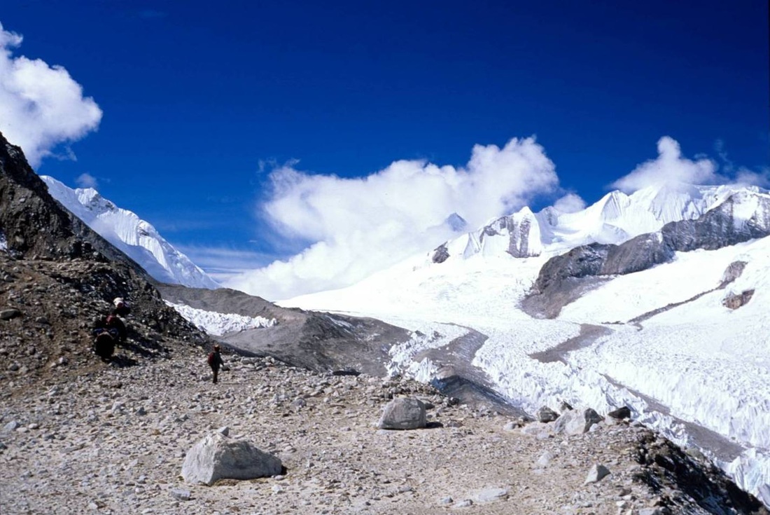
I visited Tibet and Nepal as part of an expedition to climb Cho Oyu (see Climbing an 8,000 Meter Peak). We started our journey in Kathmandu, capital of Nepal. Kathmandu has one of the most unique vibes of any city I have visited. It masterfully combines the charm of an ancient South Asian city with an anything goes beatnik colony. This feels like a city that even rock stars can disappear into without a trace.
Kathmandu is located at an elevation of approximately 1,300 meters in the rugged foothills of the Himalaya. Surrounded on all sides by mountains, its large valley is isolated and the first motor vehicles to enter the valley were airplanes.
Due to its location in the Himalaya, earthquakes are a clear and present danger throughout Nepal and a M8.5 earthquake struck the country in 1934 killing 8,500 people. Although the Nepalese government, various NGOs, and the UN have attempted to improve construction techniques to improve survivability during an earthquake, many of the buildings in Kathmandu consist of unreinforced masonry. This means that the various components of the buildings (floors, support columns and beams, and walls) are not structurally connected allowing complete freedom of movement of each of the components during an earthquake. This causes the floors to pancake on top of each other and the walls to topple over killing or injuring the residents. It's analogous to a building made with toy building blocks on a table - shake the table and the building blocks topple on top of each other. Reinforcing ties the various compenents together so that the entire building shakes as a single unit. If you were to use duct tape to connect the blocks of your toy building, then it would be less prone to collapse when you shake the table. Reinforcing, however, adds significantly to the cost of building homes. Given that Nepal is one of the poorest countries in Asia, it's simply an unaffordable luxury and most owners bet on the fact that the next earthquake will not occur within their lifetime.
Flight to Lhasa

The flight from Kathmandu to Lhasa is about 1 to 2 hours, but make sure you get a window seat. Either side of the plane is fantastic, but if you want to see Mt. Everest, you'll need to sit on the left side. During the flight, you will start out over the humid, heavily forested foothills of the Himalaya (those on the right side of the plane may also get a glimpse of the Ganges River Valley in India), fly over the backbone of the Himalaya between Mt. Everest and Kanchenjunga, and spend the last half of the journey over the Plateau of Tibet. In most parts of the world, even mountains like the Rockies or the Alps look like anthills, but you will pass Mt. Everest nearly at eye level. For geologists, this flight is a dream and I tried to get a spot in the jump seat of the cockpit, however, the crew declined my request.
Seen on the right is Mt. Everest and its satellite peak Lhotse in the right of the photo and Cho Oyu and Kyachung Kang on the left. Just after this photo was taken, the plane banked left and passed just to the right of Mt. Everest.
Seen on the right is Mt. Everest and its satellite peak Lhotse in the right of the photo and Cho Oyu and Kyachung Kang on the left. Just after this photo was taken, the plane banked left and passed just to the right of Mt. Everest.
Lhasa: The Heart of Shangri La

Tibet has been on my bucket list ever since I saw Galen Rowell's photos in National Geographic. Unfortunately, Lhasa is now more of a Chinese city than it is a Tibetan city and modern Chinese architecture now dominates the majority of the city. When I visited Lhasa in 2000, the Chinese army was ubiquitous and soldiers were posted every 100 meters on the highway from the city to the airport (a distance of about 75 kilometers). It was unfortunate to hear that even at the Jokhang, the holiest monastary in Tibet (pictured here with the Potala, former home of the Dalai Lama, in the background), Chinese security forces had placed spies within the monastary making it impossible for Tibetans to talk candidly.
Despite the impregnation of Chinese culture, Lhasa remains the spiritual and cultural center of Tibet and it was interesting to see pilgrims from all over the country converging at the Jokhang, prostrating themselves, spinning prayer wheels, and praying loudly throughout.
Despite the impregnation of Chinese culture, Lhasa remains the spiritual and cultural center of Tibet and it was interesting to see pilgrims from all over the country converging at the Jokhang, prostrating themselves, spinning prayer wheels, and praying loudly throughout.

If you find Lhasa's sino-ization disappointing, a bresh of fresh air is Shigatse, Tibet's second largest city and a 200 km drive from Lhasa. Like Lhasa, Shigatse also has a large Chinese population, but proportionally it is not as large as Lhasa and the Tibetan and Chinese sections of the city are sharply divided into two distinct districts. Here you can see Shigatse's Tibetan market.

Another site worth visiting in Shigatse is the nearby Tashilhunpo Monastary, Tibet's second holiest monastary and home to the Panchen Lama, second in command to the Dalai Lama. There is an interesting story behind the succession of the Panchen Lama in 1994 - you can read about it in Wikipedia or any other website on Tibet. Tashilhunpo is worth a visit because it receives fewer visitors than the Jokhang in Lhasa. In a scene like this, it's easy to forget what century you're living in but shortly after I took this photo, one of the monks got up and pulled out his cell phone. That's progress!

Most of the road from Lhasa to Kathmandu is unpaved and you will share the road with various other types of traffic, mechanized and non-mechanized. Although the 900 km journey sounds short, it takes at least 3 days to cover, and more like 4 or 5 if you factor in acclimitization and contingencies. Most of the road from Lhasa to Shigatse follows the Tsangpo River (which becomes the Brahmaputra when it enters India), part of the great system of Himalaya-born rivers that is the primary source of water for 25% of the world's population.
If you examine the rocks lining the banks of the Tsangpo River, you will see they are composed of marine sediments (created on the ocean floor). Tens of millions of years ago, India was separated from the rest of Asia by ocean. The Himalaya was created when India moved northward and collided into Asia. The oceanic sediments you see hundreds of miles from the nearest ocean are the remnants of that ocean that once separated India from Asia.
If you examine the rocks lining the banks of the Tsangpo River, you will see they are composed of marine sediments (created on the ocean floor). Tens of millions of years ago, India was separated from the rest of Asia by ocean. The Himalaya was created when India moved northward and collided into Asia. The oceanic sediments you see hundreds of miles from the nearest ocean are the remnants of that ocean that once separated India from Asia.

It is hard to grasp how vast the Plateau of Tibet is - it covers about 3 million square kilometers which is roughly the size of western Europe or half the continental U.S. and has an average elevation of about 4,500 meters. Another thing you will notice is how remote it is - only about 5 million people share the plateau, so you may drive for hours without seeing a single residence.
Sustaining such a large area as Tibet is geologically unstable due to a geologic principle known as isostacy. What this means is that the outer layer of the earth (the lithosphere) is a rigid layer that "floats" on top of an essentially liquid lower layer known as the asthenosphere (actually it behaves like taffy, but over geologic periods of time, we can consider it a liquid). The more mass you place on the lithosphere, the more it tends to sink into the asthenosphere below. That is what you're doing with Tibet. In fact, there are signs that Tibet is unstable and is starting to collapse under its own weight. These signs include "normal faults" which indicate that the entire region is stretching and thinning, meaning that Tibet is slowly redistributing itself over a larger area ultimately lowering its elevation. However, don't rush to visit Tibet before it sinks - it will be millions of years before humans see any significant changes.
Sustaining such a large area as Tibet is geologically unstable due to a geologic principle known as isostacy. What this means is that the outer layer of the earth (the lithosphere) is a rigid layer that "floats" on top of an essentially liquid lower layer known as the asthenosphere (actually it behaves like taffy, but over geologic periods of time, we can consider it a liquid). The more mass you place on the lithosphere, the more it tends to sink into the asthenosphere below. That is what you're doing with Tibet. In fact, there are signs that Tibet is unstable and is starting to collapse under its own weight. These signs include "normal faults" which indicate that the entire region is stretching and thinning, meaning that Tibet is slowly redistributing itself over a larger area ultimately lowering its elevation. However, don't rush to visit Tibet before it sinks - it will be millions of years before humans see any significant changes.

On day 3, we arrived in the tiny village of Tingri. Accommodations are basic to say the least: rooms consist of mud floors with straw mattresses infested with lice (we laid out our sleeping bags to avoid getting bitten); bathrooms consisted of latrines that opened straight into a pig pen (a major reason why so many flu strains originate in Asia); and if you wanted water, you had to drop a bucket into the well in the middle of the parking lot.
The food here was incredibly rich with even vegetarian selections fried in yak butter. At this altitude, the lack of oxygen means that your body is unable to digest fats and proteins and the result was a nasty case of the trots.
The food here was incredibly rich with even vegetarian selections fried in yak butter. At this altitude, the lack of oxygen means that your body is unable to digest fats and proteins and the result was a nasty case of the trots.

Here we are approaching the Himalaya. As discussed earlier, the Himalaya is created by the northward collision of India into Tibet. As India moves northward ever deeper into Asia, it is slowly losing territory. It is estimated that approximately one square kilometer of Indian territory is lost every 1,000 years - not a significant amount of land, but still disconcerting to Indians anyway.
Logistics
China occasionally bans tourist travel within Tibet due to political unrest, so check the travel advisories when planning. Independent travel is technically illegal although it is possible to travel on your own by hitchhiking. For you do -gooders out there, leave your sympathy for the Tibetans at home. Any tourists caught with Dalai Lama photos, Free Tibet T-shirts, or anything with the Tibetan flag on it will be arrested and deported. That would certainly be a pity if you spend a wad of cash and time to come only to have your trip cut short by a seemingly harmless technicality.
The best time of the year is during the pre-monsoon spring months (March to May) when it is relatively dry and clear. Avoid the summer months when the monsoons wash out sections of the road occasionally making it impassible. It is also possible to travel during the winter and fall (September to November), but damage to the road from the summer monsoons may still not be repaired in the fall, and be prepared for cold temperatures in the winter (however, temperatures will not be as cold as you might think for a region that's this high).
If you can spare the time, there are a number of side trips or different ways you can start or end the trip. A high speed railway now connects Beijing with Lhasa. Around Lhasa, there are several large lakes within a few hours drive that are stunningly beautiful. Mt. Kailas, which is a detour that takes at least several days, is one of Buddhism's holiest sites. Circumnavigating the mountain is one of the most auspicious tasks you can do in Tibetan Buddhism - it will take you about 4-5 days to accomplish the trek. Rongbuk Monastary is another detour that is famous for its views of Mt. Everest. Unfortunately, there are few options for crossing between Tibet and Nepal on foot. Should restrictions be eased, a future trek would be the crossing between Namche Bazaar in the Khumbu region of Nepal and Tingri in Tibet via the 5,800 meter high pass of Nangpa La. See my entry on Climbing an 8,000 Meter Peak to see photos on the Tibetan side of the journey.
You must be healthy and capable of spending long periods at altitudes as high as 4,500 meters to do this trip. Previous experience at these altitudes is necessary because even the healthiest and most fit people can be vulnerable. A trek to the summit of Kilimanjaro is a good indicator of how you will do in Tibet. At these altitudes, there are numerous complications that can develop and are potentially fatal. If you develop such a complication, you must evacuate to lower altitudes within a few hours or you could die. Such an evacuation is not possible in parts of Tibet. The best way to avoid altitude sickness is by ascending slowly allowing your body to acclmitize over several days thereby reducing your chances of developing altitude sickness. This is why many start their journey in Kathmandu, spending two to three nights at progressively higher altitudes . A history of cardio-pulmonary illness will preclude you from making this journey - see your doctor if in doubt. Two drugs - diamox and dexamethasone help with altitude sickness. Diamox enhances and accelerates the acclimitization process by regulating blood chemisty. Dexamethasone is a steroid and should only be taken if you develop a potentially fatal illness. Unlike diamox, dexamethasone does not help you acclimitize, it merely relieves the symptoms for a few hours and buys you time. Once the drug wears off, the symptoms return and you're back to square one.
